
geographical overview
The Dominican Republic is located east of Haiti, on the island of Hispaniola, in between the Caribbean Sea and Atlantic Ocean. The country is divided into more than twenty geographical regions. However, the main divisions are defined by the variation between the rugged highlands and fertile lowlands, which are suitable for farming. The highlands include four parallel mountain ranges, and the most prominent in the Cordillera Central, which splits the country into two parts. The Cordillera Central includes the Pico Duarte, the tallest peak in the West Indies. The lowlands of the Dominican Republic are valleys running northeast to southeast, and the longest of these is the Cibao Valley. Despite the Dominican government’s efforts to preserve the land, citizens have harmed the environment for years. The government has built national parks around the country to protect wildlife, but the rural poor are forced to cut down trees for cooking fuel, resulting in widespread deforestation. Certain zones in the oceans around the Dominican Republic are so overfished that tourist scuba divers no longer visit them. The development of facilities for tourists has also polluted the country’s environment. The Dominican Republic has also seen a steady migration of its population from rural villages to urban cities. Additionally, many villages have been abandoned during wartime and later repopulated. Despite its environmental issues, the geography of the Dominican Republic features miles of coastline and statuesque mountain ranges, which makes it an attraction for tourists from around the world.
|
hand drawn map
google map |
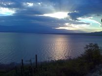
Lake Enriquillo
|
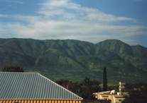
Cordillera Central
|
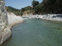
Yaque Del Norte
|
